
How to Read a Sectional Chart for Part 107: Symbols and Examples
To read a sectional chart for Part 107, decode the airport data block, identify the airspace boundary and its label, and convert between MSL and AGL. Airspace labels and MEFs are in feet MSL, obstacle heights in parentheses are AGL, and blue airports have towers while magenta airports don't.
To read a sectional chart for Part 107, decode the airport data block, find the airspace boundary and its label, and convert MSL to AGL. Airspace labels and Maximum Elevation Figures are in feet MSL, and obstacle heights in parentheses are AGL. Blue airports have a control tower and magenta airports don't. Once you can do those four things on a chart excerpt, you can answer almost every chart question on the knowledge test.
All chart examples on this page are invented for teaching. The diagrams are simplified illustrations, not FAA chart excerpts, and are not for navigation.
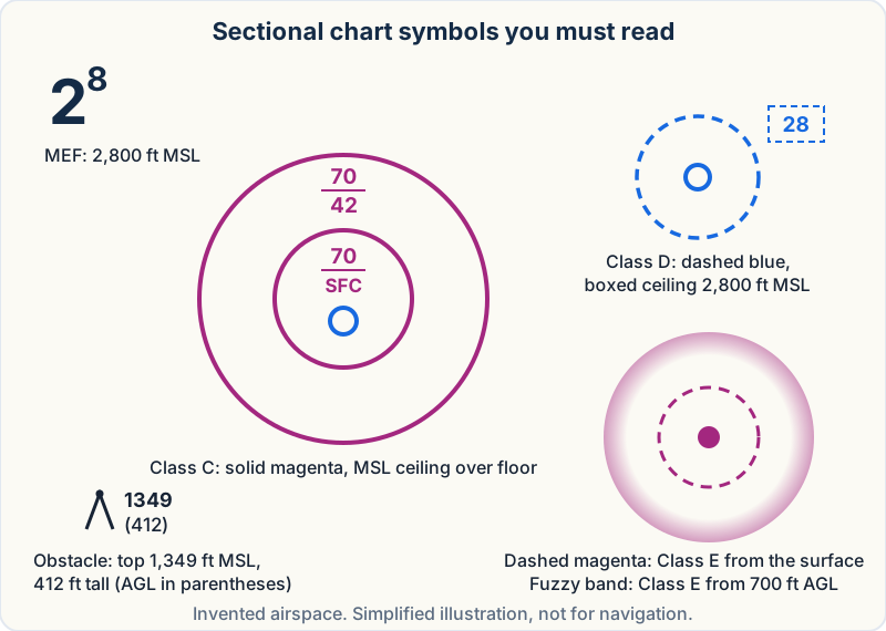 The symbols that carry most Part 107 chart questions: airspace rings and labels, an obstruction, and an MEF. Simplified illustration, not for navigation.
Key takeaways
- A sectional is the FAA's 1:500,000 VFR chart, updated every 56 days. The test gives you excerpts in the testing supplement.
- Blue airport = control tower. Magenta airport = no tower. The boundary line, not the airport color, tells you the airspace class.
- Class B and C labels are ceiling over floor in hundreds of feet MSL. Class D shows a boxed ceiling in MSL.
- On obstructions, the upper number is MSL and the number in parentheses is AGL. Ground elevation = MSL − AGL.
- MEFs are always MSL: the highest terrain or obstacle in the quadrant plus a safety margin, rounded up.
- Before comparing your flight with a shelf, add ground elevation to your planned AGL height.
What a sectional chart is and why Part 107 tests it
A Sectional Aeronautical Chart is the FAA's primary map for pilots flying by sight. The FAA Chart Users' Guide (opens in a new tab) (CUG) describes it as a 1:500,000-scale chart, which works out to about 6.9 nautical miles per inch, named after a major city in its coverage area. Sectionals are updated every 56 days. Terminal Area Charts (TACs) cover busy Class B areas at 1:250,000 and use the same symbols.
For a drone pilot, the chart answers practical questions: is my site in controlled airspace, how tall is that tower, and what frequency is local traffic on? The rule behind most of this is §107.41 (opens in a new tab), which requires ATC authorization for Class B, C and D airspace and for the surface area of Class E airspace designated for an airport. If you want the rules for each class first, read the Part 107 airspace classifications lesson. This page is about reading the paper.
On the test you get the Airman Knowledge Testing Supplement (FAA-CT-8080-2H), a booklet of chart excerpts and legend pages that the FAA lists on its testing supplements page (opens in a new tab). The FAA also publishes current sectionals free as digital VFR raster charts (opens in a new tab), so you can practice on the chart that covers your own town.
The sectional chart legend and color code
The supplement includes a legend, but you need the color code in your head to read a figure in seconds.
| What you see | What it means |
|---|---|
| Blue airport symbol and data | Airport with a control tower |
| Magenta airport symbol and data | Airport without a control tower |
| Solid blue line | Class B boundary |
| Solid magenta line | Class C boundary |
| Dashed blue line | Class D boundary |
| Dashed magenta line | Class E surface area (Class E starts at the surface) |
| Magenta vignette (fuzzy band) | Class E floor of 700 ft AGL on the fuzzy side |
| Blue vignette | Class E floor other than 700 ft (usually 1,200 ft AGL) next to Class G |
| Green to brown tints | Terrain, from low to high |
The habit that saves points: the airport color tells you about the tower, and the boundary line tells you about the airspace. A magenta airport can still sit inside a Class E surface area that needs authorization.
How to decode an airport data block
The data block is the cluster of text beside each airport symbol. The CUG explains every element, and the order is consistent from airport to airport.
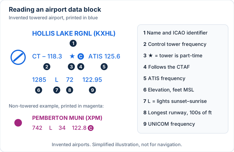 How to read an airport data block: each element in order. Invented airports, not for navigation.
Worked example 1: a towered airport
Take this invented, blue data block:
HOLLIS LAKE RGNL (KXHL)
CT – 118.3 ★ Ⓒ   ATIS 125.6
1285   L   72   122.95
| Element | What it tells you |
|---|---|
HOLLIS LAKE RGNL (KXHL) |
Airport name and location identifier |
CT – 118.3 |
Control tower primary frequency, 118.3 MHz |
★ |
The tower is part-time. Hours are in the chart's tower frequency tabulation and the Chart Supplement |
Ⓒ |
The C in a solid circle follows the CTAF, so 118.3 is the Common Traffic Advisory Frequency when the tower is closed |
ATIS 125.6 |
Automatic Terminal Information Service, the recorded airport weather and information broadcast |
1285 |
Airport elevation, 1,285 ft MSL, measured at the highest point of the usable landing area |
L |
Runway edge lights operate sunset to sunrise. *L means lighting limitations (check the Chart Supplement). A dash means no runway edge lights |
72 |
Longest runway about 7,200 ft, in hundreds of feet |
122.95 |
UNICOM, the aeronautical advisory station |
Two details trip people up. Runway length is rounded to the nearest 100 ft using 70 as the rounding point (the CUG's example: 8,070 ft is charted as 81, 8,069 ft as 80). And elevation is MSL, which you'll need for airspace math.
You may also see AWOS/ASOS frequencies, RP for right-hand traffic patterns, and dashes for missing items.
Worked example 2: a non-towered airport
PEMBERTON MUNI (XPM)
742   L   34   122.8 Ⓒ
It's magenta and there's no CT line, so there's no tower. Elevation is 742 ft MSL, lights run sunset to sunrise, and the longest runway is about 3,400 ft. The UNICOM is 122.8, and the Ⓒ after it means 122.8 is also the CTAF. That's the frequency local pilots use to announce their positions.
Part 107 doesn't require an aviation radio, but listening to the CTAF near a non-towered field is the best way to know where manned traffic is. The test checks whether you can find it.
The part-time tower star
A ★ next to a tower frequency is a prompt to look something up, not an answer. When a part-time tower closes, its Class D usually reverts to Class E (a surface area, which still needs authorization) or Class G (which doesn't). The AIM's controlled airspace section (opens in a new tab) covers how this works, and the Chart Supplement entry for the airport tells you which applies.
How airspace is shown on a sectional chart
Class B and Class C: ceiling over floor
Class B sectors (solid blue) and Class C sectors (solid magenta) carry stacked labels: ceiling on top, floor on the bottom, in hundreds of feet MSL.
70/SFCmeans surface up to 7,000 ft MSL.70/42means 4,200 ft MSL up to 7,000 ft MSL. Below 4,200 ft MSL you're under the shelf, not in it.Tas a Class C ceiling means up to, but not including, the floor of the overlying Class B.- A Class B floor preceded by
+means the Class B begins just above that altitude. At and below it, you're outside Class B.
Class D: the boxed ceiling
Class D is a dashed blue line with its ceiling in a dashed box, again in hundreds of feet MSL. A box reading 28 means surface to 2,800 ft MSL. A minus sign, as in -28, means from the surface up to but not including 2,800 ft MSL. That usually means a Class B or C shelf sits right on top.
Class E floors and Class G
A dashed magenta line means Class E begins at the surface, and §107.41 authorization applies inside it. A magenta vignette means Class E begins at 700 ft AGL on the fuzzy side. A blue vignette marks where a floor other than 700 ft, normally 1,200 ft AGL, borders Class G. Floors above 700 ft that aren't the default are labeled with their value.
Where you see no boundary at all, Class G typically runs from the surface up to the 1,200 ft AGL Class E floor. For a 400 ft AGL drone flight, both the 700 ft and 1,200 ft floors are above you, so you're in Class G. The free lesson on controlled vs. uncontrolled airspace walks through that logic with more pictures.
Special use airspace and other areas
- Prohibited, restricted and warning areas have hatched borders labeled
P-,R-andW-plus a number. Their margin tabulation is printed in blue. - MOAs and alert areas are labeled by name ("... MOA") or
A-plus a number. Their tabulation is printed in magenta. - The SUA tabulation in the margin lists altitudes, times of use, and controlling agency. No NOTAM is issued for permanently listed times.
- National Security Areas are a broken magenta line. Only national security TFRs are charted (broken blue line); every other TFR exists only as a NOTAM.
- Military Training Routes show as route centerlines with solid black designators such as
VRorIRplus digits, with small arrowheads for direction. - A thin solid magenta ring about 30 NM around a Class B primary airport marks the Mode C veil. Don't mistake it for the Class B boundary.
Obstacles, terrain, and Maximum Elevation Figures
Reading obstruction symbols: MSL vs. AGL
The CUG says sectionals typically show man-made obstacles more than 200 ft AGL, or more than 299 ft AGL inside the yellow tint of city areas. There are separate symbols for obstacles under 1,000 ft AGL and for those 1,000 ft AGL or taller, plus variants for lighted obstacles, groups of obstacles, and wind turbines.
Each obstacle usually carries two numbers:
1349     ← top of the obstacle, feet MSL
(412)    ← height of the obstacle, feet AGL
Parentheses mean AGL. In very congested areas the AGL value may be left off. UC next to an obstacle means it's under construction or reported but not yet verified. A group obstacle symbol shows only the highest of several.
Worked example 3: ground elevation from an obstacle
A tower beside your survey site reads 1349 (412). The ground at its base is 1,349 − 412 = 937 ft MSL. If your site is on the same level ground, a 400 ft AGL flight tops out at 937 + 400 = 1,337 ft MSL.
Now use the structure rule. §107.51(b) (opens in a new tab) lets you fly higher than 400 ft AGL only within a 400 ft radius of a structure, and no higher than 400 ft above its immediate uppermost limit. Inspecting this tower, you could climb to 1,349 + 400 = 1,749 ft MSL, which is 812 ft AGL. Airspace still applies on top of that, so check for a shelf or Class E surface area overhead. Step away from the tower and the normal 400 ft AGL limit is back.
What isn't on the chart
A 180 ft tower in open country or a 280 ft building downtown may not be charted at all, and wires and new construction can be missing. The chart starts your site survey. It doesn't replace it.
Terrain and Maximum Elevation Figures
The CUG lists five ways the chart shows the land: contour lines, shaded relief, color tints, obstruction symbols, and Maximum Elevation Figures. Spot elevations, small dots with a number in feet MSL, mark hilltops.
Each quadrant, bounded by the ticked lines every 30 minutes of latitude and longitude, shows an MEF in large and small numerals. A large 2 followed by a small 8 reads 2,800 ft MSL. The CUG builds it like this:
| Highest feature in the quadrant | How the MEF is computed |
|---|---|
| Man-made obstacle | Obstacle top (MSL) + 100 ft possible vertical error, rounded up to the next 100 ft |
| Natural terrain or tree | Elevation + 100 ft vertical error + 200 ft allowance for uncharted obstacles, rounded up |
So an MEF is always MSL, it covers the whole quadrant, and it's deliberately conservative. It isn't the height of any one object.
Latitude, longitude, and distance on a sectional
Latitude lines run east–west and count degrees north of the equator. Longitude lines run north–south and count degrees west of the prime meridian. Each degree has 60 minutes. Sectionals draw both every 30 minutes and tick the minutes along them. Coordinates are written latitude first, for example 41°15′N, 096°40′W.
To plot a point, count minutes north from the latitude line below it and west from the longitude line east of it. West longitude grows to the left, and that's where most plotting mistakes happen.
Worked example 4: measuring distance
Two points sit on the same meridian at 41°10′N and 41°28′N. That's 18 minutes of latitude. One minute of latitude equals one nautical mile, so they're 18 NM apart, about 20.7 statute miles (1 NM ≈ 1.15 SM). Don't count longitude minutes for distance. They shrink as the meridians converge toward the pole.
Worked examples: MSL and AGL math on the chart
This is the most heavily tested chart skill. Airspace labels are MSL and your drone flies in AGL, so you have to convert.
Your altitude (MSL) = ground elevation (MSL) + planned height (AGL)
Height of airspace above a spot (AGL) = charted altitude (MSL) − ground elevation (MSL)
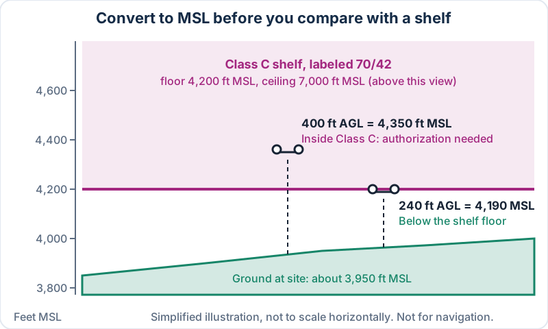 Shelves are flat in MSL, so rising terrain eats your margin. Simplified illustration, not for navigation.
Worked example 5: a site under a Class C shelf
A utility survey site sits under a Class C shelf labeled 70/42. Contour lines and a nearby spot elevation put the ground at about 3,950 ft MSL. You plan to fly at 400 ft AGL.
- Convert your flight to MSL: 3,950 + 400 = 4,350 ft MSL.
- Read the shelf floor:
42= 4,200 ft MSL. - Compare: 4,350 is above 4,200, so the flight enters Class C and needs ATC authorization under §107.41.
- Find your unauthorized ceiling: 4,200 − 3,950 = 250 ft. Stay below 250 ft AGL and you're under the shelf, as long as nothing else applies.
Shelves are flat in MSL, so over high ground the floor can be only a few hundred feet above you. That's the trap the test likes.
Worked example 6: how tall is this Class D?
An invented towered airport has an elevation of 820 ft MSL, and its Class D box reads -28. The Class D runs from the surface up to, but not including, 2,800 ft MSL. Above the field, that's 2,800 − 820 = 1,980 ft AGL of Class D. A question asking for the Class D ceiling wants 2,800 ft MSL, not 1,980 ft. Read what's asked.
How to answer sectional chart questions on the test
- Find the reference point first. Locate "area 3" or "the airport northeast of the town" before reading the answer choices.
- List every symbol around it: airport color, boundary lines and labels, obstacles, and the quadrant's MEF.
- Underline MSL or AGL in the question. Wrong answers often use the right number with the wrong reference.
- Floor or ceiling? Shelf questions often ask for one and offer the other.
- Use the supplement's legend instead of guessing a symbol from memory.
The guide to how hard the Part 107 exam is explains the test format. Chart work rewards repetition, so give it dedicated sessions in your Part 107 study plan.
Common sectional chart mistakes
- Reading the parenthesized obstacle number as MSL. Parentheses are AGL.
- Treating an MEF as AGL. It's MSL and covers the whole quadrant.
- Comparing AGL flight height directly with an MSL shelf label. Convert first.
- Assuming magenta means no authorization. A dashed magenta Class E surface area needs it.
- Ignoring the star. A part-time tower can change the airspace class after hours.
- Misreading
Tor the minus sign.Tends at the Class B floor. A minus means "up to but not including." - Confusing the 30 NM Mode C ring with the Class B boundary.
Practice questions
1. An obstruction is labeled 2117 over (498). What is the ground elevation at its base?
- A. 498 ft MSL
- B. 1,619 ft MSL
- C. 2,615 ft MSL
Show answer
B. 2,117 ft is the MSL top and 498 ft is the AGL height. 2,117 − 498 = 1,619 ft MSL.
2. A site has ground elevation 1,640 ft MSL under a Class C shelf labeled 48/20. What is the highest you can fly without authorization?
- A. Below 360 ft AGL
- B. 400 ft AGL
- C. Below 2,000 ft AGL
Show answer
A. The floor is 2,000 ft MSL. 2,000 − 1,640 = 360 ft, so stay below 360 ft AGL to remain under the shelf.
More questions like these, with explanations, are on the free Part 107 practice test.

Frequently asked questions
What do the numbers in parentheses on a sectional chart mean?
The number in parentheses under an obstruction is its height above ground level (AGL). The number above it is the elevation of the obstacle's top in feet MSL. Subtract the AGL height from the MSL top to get the ground elevation at its base. This is one of the most common chart questions on the Part 107 test, and the wrong answers usually swap the two.
Are sectional chart altitudes MSL or AGL?
Almost everything on a sectional is MSL: airport elevations, Class B, C and D labels, MEFs, spot elevations, and obstacle tops. The exceptions are obstacle heights in parentheses (AGL) and the Class E floors shown by vignettes, which are 700 ft or 1,200 ft AGL. When in doubt, assume MSL and look for parentheses or a vignette.
What does the magenta shading around an airport mean for a drone pilot?
The fuzzy magenta band (vignette) means Class E airspace begins at 700 ft AGL on the shaded side. Below 700 ft it's normally Class G, so a 400 ft AGL drone flight there doesn't need ATC authorization. A dashed magenta line is different: Class E starts at the surface, and §107.41 authorization applies.
Do I get a sectional chart legend during the Part 107 test?
Yes. The testing supplement (FAA-CT-8080-2H) includes legend pages alongside the chart figures, and you have it during the test, so you don't need to memorize rare symbols. Know the common ones cold anyway, because looking up every symbol eats time on a timed test.
Does Part 107 require me to carry a sectional chart?
No Part 107 rule requires you to carry a paper sectional. You do have to know the airspace you're in and get authorization where §107.41 requires it, and sectionals are one of the clearest ways to check. Many pilots use the FAA's free digital charts. Whatever you use, make sure it's current.
What does a star next to a tower frequency mean?
A star (★) after the control tower frequency means the tower is part-time. When it closes, the Class D usually becomes Class E or Class G, and the frequency marked with the CTAF symbol becomes the one for self-announced traffic. Check the Chart Supplement for the hours and the after-hours airspace class.
If you want structured chart drills with feedback, the Part 107 course has a full sectional chart module. The Part 107 study guide shows where charts fit among the other test topics.
Sources
- FAA Aeronautical Chart Users' Guide (VFR Terms and Symbols), effective 9 July 2026
- FAA Airman Knowledge Testing Supplements (FAA-CT-8080-2H)
- FAA VFR Raster Charts (free digital sectionals)
- FAA Aeronautical Information Manual, Chapter 3, Section 2 — Controlled Airspace
- 14 CFR §107.41 — Operation in certain airspace
- 14 CFR §107.51 — Operating limitations for small unmanned aircraft
- FAA Remote Pilot – Small Unmanned Aircraft Systems Study Guide (FAA-G-8082-22)