
Part 107 Weather: Theory, Hazards, and Exam Questions Explained
Part 107 weather questions cover density altitude, atmospheric stability, fronts, thunderstorms and microbursts, fog, wind, icing, and official weather sources. Know what raises density altitude, how stable and unstable air look, the three thunderstorm stages, which fog types need wind, and where to get METARs, TAFs and briefings.
Part 107 weather questions cover density altitude, stability, fronts, thunderstorms and microbursts, fog, wind, icing, and official weather sources, the knowledge area listed in 14 CFR §107.73(c) (opens in a new tab). Most questions ask you to recognize conditions that cut drone performance or safety: hot, high, humid air; unstable air and storms; fog that forms as the temperature/dewpoint spread closes. Decoding the actual reports is covered in the METAR and TAF lesson.
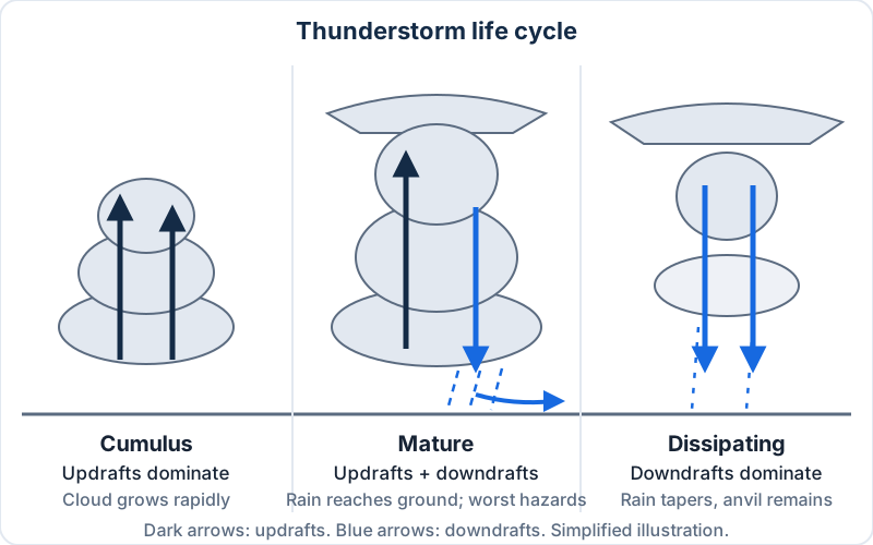 The thunderstorm life cycle, one of the most-tested weather topics. Simplified illustration.
Key takeaways
- High, hot and humid air raises density altitude and reduces lift, thrust and power. Temperature has the biggest effect.
- Unstable air: cumulus clouds, showers, turbulence, good visibility. Stable air: layered clouds, steady rain, smooth air, haze.
- Thunderstorms need moisture, unstable air and lift. Updrafts dominate the cumulus stage, both drafts the mature stage, and downdrafts the dissipating stage.
- A microburst can last 5 to 15 minutes and produce downdrafts up to 6,000 ft per minute. No small drone outruns that.
- Radiation fog forms on calm, clear nights. Advection and upslope fog need wind.
- Structural icing needs visible moisture at or below freezing. Remove all frost before flight.
Why weather matters under Part 107
The rules make weather your job. Under §107.49 (opens in a new tab), before every flight the remote pilot in command must assess the operating environment, including local weather conditions. Then §107.51 (opens in a new tab) sets hard limits:
| §107.51 limit | Value |
|---|---|
| Flight visibility from the control station | At least 3 statute miles |
| Distance below clouds | At least 500 ft |
| Horizontal distance from clouds | At least 2,000 ft |
| Maximum altitude | 400 ft AGL (or within 400 ft of a structure, up to 400 ft above its top) |
Nothing in Part 107 sets a wind limit. Your aircraft's manufacturer does, and your judgment does. The theory below is how you predict whether conditions will hold for the length of the job. The FAA regulations lesson covers the rest of the operating rules.
The standard atmosphere and lapse rates
Aviation measures everything against a reference atmosphere. Performance numbers, altimeters, and most exam math assume it.
| Value | Standard |
|---|---|
| Sea-level temperature | 15 °C (59 °F) |
| Sea-level pressure | 29.92 inHg (1,013.2 mb) |
| Standard temperature lapse rate | 2 °C (3.5 °F) per 1,000 ft |
| Pressure lapse rate (lower atmosphere) | About 1 inHg per 1,000 ft |
| Dry adiabatic lapse rate (unsaturated air rising) | 3 °C (5.4 °F) per 1,000 ft |
| Moist adiabatic lapse rate (saturated air rising) | About 1.1–2.8 °C (2–5 °F) per 1,000 ft |
Quick check: the standard temperature at 6,000 ft is 15 − (6 × 2) = 3 °C. If it's actually 30 °C there, the air is 27 °C warmer than standard. Hold that thought.
What is density altitude, and how does it affect a drone?
The Aviation Weather Handbook (FAA-H-8083-28B) (opens in a new tab) defines density altitude as pressure altitude corrected for temperature deviations from the standard atmosphere. Put simply, it's the altitude your aircraft "feels" based on how thin the air is. Higher density altitude means less dense air, and the handbook lists three effects:
- It reduces power, because an engine takes in less air.
- It reduces thrust, because a propeller has less air to work with.
- It reduces lift, because thin air exerts less force on airfoils.
Your drone's rotors are airfoils. In thin air they have to spin faster to make the same thrust, so expect a slower climb, less payload margin, and higher battery draw.
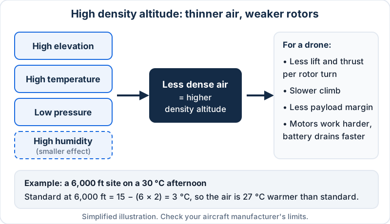 What raises density altitude, and what it does to a multirotor. Simplified illustration.
What raises density altitude
- High elevation: lower pressure, thinner air.
- High temperature: the AWH calls temperature the most important factor.
- Low pressure: a passing low raises density altitude even at a fixed site.
- High humidity: water vapor is lighter than dry air, so humid air is slightly less dense. The PHAK counts it as a contributor. The AWH says the effect is generally negligible next to temperature.
On the test, "high, hot and humid" is the combination that produces the highest density altitude. That's the answer.
Worked example: a mountain job on a summer afternoon
You're mapping a quarry at about 6,000 ft pressure altitude, and it's 30 °C at 3 p.m. Standard temperature there is 3 °C, so you're 27 °C above standard. A common rule of thumb adds roughly 120 ft of density altitude per degree Celsius above standard: 27 × 120 ≈ 3,240 ft. Your drone is performing as if it were near 9,200 ft. That's an estimate, not a chart reading, but it tells you what you need: fly the heavy-payload legs in the cool morning, and check the manufacturer's service ceiling and payload limits.

Stable vs. unstable air: how to tell them apart
Stability is the atmosphere's resistance to vertical motion. In stable air, a parcel you push upward ends up cooler than its surroundings and sinks back. In unstable air, a lifted parcel stays warmer and keeps rising, so small motions grow into convection and towering clouds. Warm, moist air is the least stable. Cool, dry air is the most stable.
| Characteristic | Stable air | Unstable air |
|---|---|---|
| Clouds | Stratiform (layered), fog | Cumuliform (heaped, vertical growth) |
| Precipitation | Steady, continuous | Showery |
| Air | Smooth | Turbulent |
| Visibility | Fair to poor in haze and smoke | Good, except in blowing dust or sand |
A temperature inversion is a layer where temperature increases with height. It's very stable and acts like a lid, trapping haze, smoke and fog beneath it. The most common is a surface inversion on a clear, calm night. The trap for drone pilots is the top of the inversion: you can climb out of calm air into a strong wind a few hundred feet up.
The exam often gives you a set of observations and asks which kind of air you're in. Puffy cumulus building by noon and a bumpy ride? Unstable. Gray overcast, drizzle and haze? Stable.
Air masses and fronts
An air mass takes on the temperature and moisture of its source region: continental (c, dry) or maritime (m, moist), polar (P) or tropical (T). An mT air mass from the Gulf is warm and moist; a cP air mass from Canada is cool and dry. When an air mass moves over a warmer surface, it's heated from below and becomes unstable. Over a colder surface, it becomes stable, with low stratus and fog.
A front is the boundary between two air masses. Expect a wind shift and a change in temperature and dewpoint at any frontal passage.
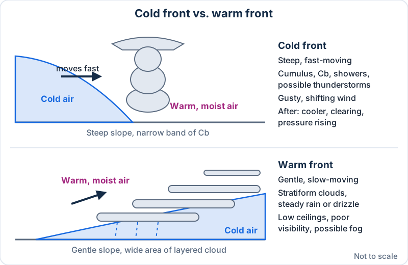 Cold fronts are steep and fast. Warm fronts are shallow and slow. Simplified illustration, not to scale.
| Cold front | Warm front | |
|---|---|---|
| Slope and speed | Steep, faster | Gentle, slower |
| Clouds | Towering cumulus, cumulonimbus | Stratiform, lowering and thickening |
| Precipitation | Showers, possible thunderstorms, narrow band | Steady rain or drizzle, wide area |
| Wind | Gusty, variable, shifting | Lighter, gradual shift |
| After passage | Cooler, drier, clearing, pressure rising | Warmer, slow improvement |
A stationary front is one where neither air mass advances, and its weather can sit over you for days. An occluded front forms when a fast cold front catches a warm front, combining features of both. A squall line, a narrow band of active thunderstorms often along or ahead of a cold front, is described in the PHAK's weather theory chapter (opens in a new tab) as the single most intense weather hazard to aircraft.
Practical read: a warm front can cost you a whole day of low ceilings and poor visibility. A cold front usually costs you a few rough hours, then gives you clear, gusty air behind it.
Wind near the ground: turbulence and wind shear
At 200 ft, local effects matter more than the weather map.
- Mechanical turbulence forms when wind flows over buildings, trees and ridges. It's strongest on the downwind (leeward) side. Flying a roof inspection on the lee side of a building in a 20 kt wind is a reliable way to lose control.
- Mountain and ridge winds flow smoothly up the windward side and tumble down the lee side. The FAA's remote pilot study guide says mountain-top winds over 25 kt suggest turbulence and winds over 40 kt dictate caution.
- Low-level wind shear is a sudden change in wind speed or direction over a short distance. It's associated with fronts, thunderstorms, temperature inversions and strong upper-level winds.
- Local breezes: a sea breeze blows onshore during the day, and a land breeze blows offshore at night. Valley breezes flow upslope by day; mountain breezes flow downslope at night.
Thunderstorms and microbursts
What a thunderstorm needs
The AWH lists three ingredients: sufficient water vapor, unstable air, and a lifting mechanism. Lift can come from surface heating, fronts, upslope flow, converging winds, or outflow from earlier storms.
The three stages
| Stage | What dominates | What you see |
|---|---|---|
| Cumulus (towering cumulus) | Updrafts | Cloud grows fast; updrafts can exceed 3,000 fpm |
| Mature | Updrafts and downdrafts together | Precipitation reaches the surface; lightning, hail, gust front; hazards peak |
| Dissipating | Downdrafts | Rain tapers off; a remnant anvil is left |
The AWH says a single cell's life cycle is typically about 30 minutes. In the mature stage the downdraft spreads out along the ground as a gust front, which can arrive well before the rain. Hail can fall from clear air near the storm. Since you can't tell from the ground which hazards a storm holds, treat every thunderstorm as having all of them.

Microbursts
A microburst is a small, intense downdraft that spreads out in all directions when it hits the ground. The AWH calls it the most severe type of wind shear and gives these typical numbers:
- Horizontal diameter under 2.5 miles (the PHAK says 1–2 miles), about 1,000 ft deep
- Lifespan about 5–15 minutes
- Downdrafts up to 6,000 ft per minute, with headwind losses of 30–90 kt
Clues include an intense rain shaft, virga (rain evaporating before it reaches the ground), and a ring of blowing dust. A 6,000 fpm downdraft is about 68 mph straight down. No consumer or commercial multirotor climbs against that. The only defense is distance: land when you see convective weather building and wait it out.
Moisture, dewpoint, and fog
Dewpoint is the temperature the air must cool to for saturation. When temperature and dewpoint are close (a small spread), expect fog, low clouds or precipitation, especially when the spread is shrinking in the evening or early morning.
Worked example: estimating cloud base
Rising unsaturated air and its dewpoint converge at about 4.4 °F per 1,000 ft. Divide the spread in °F by 4.4 to estimate the base of cumuliform clouds in thousands of feet AGL.
- Temperature 85 °F, dewpoint 71 °F: spread 14 °F. 14 ÷ 4.4 ≈ 3.2, so bases near 3,200 ft AGL.
- Temperature 9 °C, dewpoint 8 °C: spread 1 °C. That's roughly 400 ft by the Celsius version of the rule (about 2.5 °C per 1,000 ft). Expect fog or very low cloud.
Fog types
| Fog type | How it forms | Wind | Exam clue |
|---|---|---|---|
| Radiation | Ground cools on clear nights, chilling the air to its dewpoint | Calm or light | Low-lying areas; burns off after sunrise. Under 20 ft deep is ground fog |
| Advection | Moist air moves over a colder surface | Needed; deepens up to about 15 kt, lifts into stratus above that | Coastal; can persist |
| Upslope | Moist, stable air is pushed up sloping terrain and cools | Needed; 5–15 kt most favorable | Can form under cloudy skies; often dense and deep |
| Steam (sea smoke) | Cold, dry air moves over warmer water | Cold air must flow over the water | Low-level turbulence and icing possible |
| Ice fog | Water vapor turns to ice crystals in very cold air | Like radiation fog | Usually −25 °F or colder |
The classic trap: wind clears radiation fog, but advection and upslope fog need wind to form.
Icing and frost
Structural icing needs visible moisture (rain or cloud droplets) and a temperature at or below freezing where the moisture hits the aircraft. Supercooled droplets freeze on contact. Large drops, such as freezing rain, form heavy clear ice. Small drops form rough rime ice.
You won't fly through clouds under Part 107, but freezing drizzle, freezing rain and freezing fog can reach you near the ground. A thin coat of ice on small propeller blades changes their shape, cutting thrust and adding weight.
Frost forms on clear, calm nights when surfaces cool below a dewpoint that's below freezing. It disrupts airflow, reduces lift and increases drag. A drone that sat in the truck bed overnight can be frosted. Remove all frost before flight, and expect reduced battery performance in the cold.
Where to get official aviation weather
| Source | What you get |
|---|---|
| METAR / SPECI | Current surface observation at an airport, usually hourly, with specials when conditions change |
| TAF | Forecast for the area within 5 SM of an airport's runway complex, usually 24 or 30 hours |
| aviationweather.gov (opens in a new tab) | METARs, TAFs, Graphical Forecasts for Aviation (GFA), AIRMETs, SIGMETs, PIREPs |
| Flight Service (1800wxbrief.com) (opens in a new tab) | Online briefings, NOTAMs and TFRs, or call 1-800-WX-BRIEF |
Part 107 doesn't name a required weather source. It requires you to assess local weather. The how to read a METAR and TAF lesson turns those coded reports into a go/no-go check.
A preflight weather routine for drone jobs
- Day before: check the GFA and the nearest TAF for your window. Look for fronts, storms, and wind.
- Morning of: read the latest METAR and TAF. Note the spread, the trend, and any SPECIs.
- Do the density altitude math if the site is high or the day is hot and you're carrying a payload.
- On site: look at the sky and feel the wind. The airport may be miles away and hundreds of feet lower.
- During the flight: watch for building cumulus, a darkening sky, a sudden wind shift, or a gust front. Land early.
Common Part 107 weather mistakes
- Saying humid air is denser. It's slightly less dense, so it raises density altitude.
- Mixing up stability clues. Cumulus and showers mean unstable; layers and steady rain mean stable.
- Reversing the thunderstorm stages. Updrafts, then both, then downdrafts.
- Assuming wind clears all fog. Advection and upslope fog need it.
- Ignoring a shrinking spread at dawn or dusk.
- Trusting the 3 SM minimum as "safe." Visibility can be legal under a building thunderstorm.
Practice questions
1. Which combination produces the highest density altitude?
- A. Low elevation, cool, dry air
- B. High elevation, hot, humid air
- C. High elevation, cool, dry air
Show answer
B. Elevation, heat and humidity all reduce air density, raising density altitude. Temperature has the largest effect.
2. Warm, moist air moving over a cooler coastal surface with a light wind most likely produces
- A. advection fog
- B. radiation fog
- C. steam fog
Show answer
A. Advection fog forms when moist air moves over a colder surface, and it needs wind. Steam fog is the reverse: cold air over warmer water.
Try a full set of timed weather questions on the free Part 107 practice test.
Frequently asked questions
What weather topics are on the Part 107 test?
The Part 107 test covers weather sources and weather's effects on small UAS performance, the knowledge area in §107.73(c). In practice that means density altitude, stability, air masses and fronts, thunderstorms and microbursts, wind and turbulence, fog, icing, and reading METARs and TAFs. See the Part 107 study guide for how weather fits with the other topics.
Does density altitude matter for drones?
Yes. Density altitude affects any aircraft that relies on air for lift and thrust, and rotors are airfoils. In thin air, a multirotor needs more power for the same thrust, so it climbs more slowly, carries less, and drains its battery faster. High, hot sites on summer afternoons are where you'll notice it most.
What is the difference between stable and unstable air?
Stable air resists vertical motion, so it brings layered clouds, steady precipitation, smooth air, and often haze or fog. Unstable air encourages vertical motion, so it brings cumulus clouds, showers, turbulence, and generally good visibility. On the test, match the clue to the air type: cumuliform means unstable, stratiform means stable.
What are the three stages of a thunderstorm?
The three stages are cumulus (also called towering cumulus), mature, and dissipating. Updrafts dominate the cumulus stage. In the mature stage, precipitation reaches the ground and updrafts and downdrafts exist side by side, so hazards peak. In the dissipating stage, downdrafts dominate and the storm rains itself out.
Is there a wind limit for Part 107 drones?
No. Part 107 sets visibility, cloud clearance, altitude and speed limits, but no wind limit. You're still required under §107.49 to assess local weather before each flight, and your aircraft's manufacturer usually publishes a maximum wind resistance. Gusts, turbulence near structures, and wind shear at an inversion top are the real-world concerns.
Can I fly a drone in fog?
Only if you can still meet §107.51: at least 3 statute miles of flight visibility from the control station, and at least 500 ft below and 2,000 ft horizontally from clouds. Fog is a cloud at the surface, so in dense fog you can't keep the required distance or see your aircraft. Light mist with good visibility may be legal.
Weather is a common weak spot on the exam. The guide to how hard the Part 107 exam is explains the test format, and the Part 107 course has a full weather module with checks after each lesson.
Sources
- 14 CFR §107.73 — Knowledge and training
- 14 CFR §107.49 — Preflight familiarization, inspection, and actions for aircraft operation
- 14 CFR §107.51 — Operating limitations for small unmanned aircraft
- FAA-H-8083-28B, Aviation Weather Handbook (page last updated April 13, 2026)
- FAA-H-8083-25C, Pilot's Handbook of Aeronautical Knowledge — Chapter 12, Weather Theory
- FAA Remote Pilot – Small Unmanned Aircraft Systems Study Guide (FAA-G-8082-22)
- NWS Aviation Weather Center — aviationweather.gov
- Flight Service — 1800wxbrief.com