
How to Read a METAR and TAF: Part 107 Decoding Guide
To read a METAR, decode its groups in order: type, station, UTC time, wind, visibility, weather, sky condition, temperature/dewpoint, altimeter, and remarks. For Part 107, confirm at least 3 statute miles of visibility and stay 500 ft below and 2,000 ft horizontally from the lowest cloud of any coverage.
To read a METAR, decode its groups in order: report type, station, UTC time, wind, visibility, weather, sky condition, temperature/dewpoint, altimeter, then remarks. For a Part 107 check, confirm at least 3 statute miles of visibility, then find the lowest cloud of any coverage and make sure you can stay 500 ft below it and 2,000 ft horizontally away (14 CFR §107.51). A TAF uses the same codes to forecast the next 24 or 30 hours.
Every report on this page is an original teaching example. The station identifiers (KXRA to KXRE) are fictitious placeholders, not real airports.
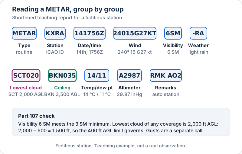 A METAR decoded group by group, with the Part 107 check at the bottom. Fictitious station.
Key takeaways
- METAR = routine hourly observation. SPECI = special report when conditions change significantly. TAF = airport forecast.
- Times are UTC (Z), wind directions are true, speeds are knots, visibility is statute miles, cloud heights are hundreds of feet AGL, temperatures are °C.
- The ceiling is the lowest BKN, OVC or VV layer. Part 107 cloud clearance uses the lowest cloud of any coverage, including FEW and SCT.
Min the temperature group means minus, not missing.P6SMmeans more than 6 SM.- In a TAF, FM replaces everything before it, TEMPO is a brief fluctuation, and PROB30 is a 30% chance.
What METAR, SPECI and TAF mean
A METAR is an aviation routine weather report, produced near the top of each hour. A SPECI is an unscheduled special report with the same format, issued between METARs when a criterion in the Aviation Weather Handbook (FAA-H-8083-28B) (opens in a new tab) is met. Those include visibility dropping below 3, 2 or 1 mile, a ceiling forming or changing through 3,000, 1,500, 1,000 or 500 ft, a thunderstorm beginning or ending, and a wind shift of 45° or more in under 15 minutes with speeds of 10 kt or more.
A TAF (terminal aerodrome forecast) covers the area within 5 SM of the center of an airport's runway complex. Most cover 24 hours; some major airports get 30. You'll find both on the Aviation Weather Center's METAR page (opens in a new tab) and TAF page (opens in a new tab). For the weather theory behind the codes, see the Part 107 aviation weather lesson.
METAR groups in order
When an element doesn't occur, its group is left out. The order never changes.
| # | Group | Example | Meaning |
|---|---|---|---|
| 1 | Type | METAR, SPECI |
Routine or special |
| 2 | Station | KXRA |
Four-letter ICAO identifier |
| 3 | Date/time | 141756Z |
14th of the month, 1756 UTC |
| 4 | Modifier | AUTO, COR |
Fully automated; corrected |
| 5 | Wind | 24015G27KT |
From 240° true, 15 kt, gusts 27 kt |
| 6 | Variable direction | 210V280 |
Direction varying 210° to 280° |
| 7 | Visibility | 6SM, 1 3/4SM |
Prevailing visibility in statute miles |
| 8 | Runway visual range | R17L/2600FT |
When reported |
| 9 | Weather | -RA, +TSRA, FZFG |
Intensity, descriptor, phenomenon |
| 10 | Sky condition | SCT020 BKN035 |
Coverage + height in hundreds of ft AGL |
| 11 | Temp/dewpoint | 14/11, M04/M05 |
°C; M = minus |
| 12 | Altimeter | A2987 |
29.87 inHg |
| 13 | Remarks | RMK AO2 ... |
Extra coded information |
Wind
Direction is where the wind blows from, in degrees true, followed by speed in knots. G marks gusts, which are reported when speed varies by 10 kt or more between peaks and lulls. VRB04KT means variable direction at 6 kt or less. A dddVddd group follows when direction varies by 60° or more at speeds above 6 kt. Calm is 00000KT.
Visibility
Prevailing visibility in statute miles. A space separates whole miles from fractions, so 1 1/2SM is one and a half miles, not eleven halves. M1/4SM means less than a quarter mile.
Weather codes
Weather is built from up to three parts: intensity or proximity, a descriptor, and the phenomenon.
| Type | Codes |
|---|---|
| Intensity | - light, no sign moderate, + heavy |
| Proximity | VC in the vicinity, 5 to 10 SM from the station |
| Descriptor | TS thunderstorm, SH showers, FZ freezing, BL blowing, DR low drifting, MI shallow, BC patches, PR partial |
| Precipitation | RA rain, DZ drizzle, SN snow, PL ice pellets, GR hail, GS small hail or snow pellets, UP unknown |
| Obscuration | BR mist, FG fog, HZ haze, FU smoke, DU dust, SA sand, VA volcanic ash |
| Other | SQ squall, FC funnel cloud (+FC tornado or waterspout), DS dust storm, SS sandstorm |
The AWH ties fog codes to visibility: FG is reported when visibility is below 5/8 SM, and BR or HZ from 5/8 SM to less than 7 SM. FZFG means fog at temperatures below 0 °C.
Sky condition and the ceiling
Each layer is coverage plus height in hundreds of feet AGL, lowest first.
| Code | Coverage |
|---|---|
FEW |
1/8 to 2/8 |
SCT |
3/8 to 4/8 |
BKN |
5/8 to 7/8 |
OVC |
8/8 |
VV |
Vertical visibility into an indefinite ceiling (sky obscured) |
SKC / CLR |
No clouds (SKC from an observer; CLR from an automated station, nothing at or below 12,000 ft) |
CB or TCU can follow a layer for cumulonimbus or towering cumulus. The ceiling is the lowest layer reported as BKN or OVC, or the VV value. FEW and SCT are never a ceiling.
One more contrast worth making: METAR cloud heights are AGL, while almost everything on a sectional chart is MSL.
Temperature, dewpoint and altimeter
14/11 is 14 °C with an 11 °C dewpoint. M04/M05 is −4 °C and −5 °C. A small spread warns of fog or low cloud. A2987 is an altimeter setting of 29.87 inHg.
Common remarks
| Remark | Meaning |
|---|---|
AO1 / AO2 |
Automated station without / with a precipitation discriminator |
PK WND 31041/15 |
Peak wind 310° at 41 kt at 15 minutes past the hour |
WSHFT 13 FROPA |
Wind shift began at :13, due to a frontal passage |
TSB12, SNB32 |
Thunderstorm began at :12; snow began at :32 |
PRESRR / PRESFR |
Pressure rising / falling rapidly |
SLP115 |
Sea-level pressure 1011.5 mb (SLP982 = 998.2 mb) |
P0002 |
0.02 in. of precipitation in the past hour |
T01440106 |
Temperature 14.4 °C, dewpoint 10.6 °C (a leading 1 means minus) |
How to read a METAR: six worked examples
Example 1: routine report with gusts and rain
METAR KXRA 141756Z 24015G27KT 210V280 6SM -RA SCT020 BKN035 OVC080 14/11 A2987 RMK AO2 SLP115 P0002 T01440106
Routine report, 14th at 1756 UTC. Wind from 240° true at 15 kt gusting 27, direction varying 210° to 280°. Visibility 6 SM in light rain. Scattered at 2,000 ft, broken at 3,500 ft (the ceiling), overcast at 8,000 ft. Temperature 14 °C, dewpoint 11 °C. Altimeter 29.87. Remarks: automated with a precipitation discriminator, sea-level pressure 1011.5 mb, 0.02 in. of rain in the past hour, precise temperature 14.4 °C and dewpoint 10.6 °C.
Part 107 check. 6 SM meets the 3 SM minimum. The lowest cloud is SCT at 2,000 ft, so 500 ft below it is 1,500 ft, and the 400 ft AGL limit governs. Legal. Whether your aircraft and your judgment accept 27 kt gusts is a separate question under §107.49.
Example 2: automated report in freezing fog
METAR KXRB 080253Z AUTO 00000KT 1/2SM FZFG VV002 M04/M05 A3021 RMK AO2 SLP243 T10411050
Fully automated, 8th at 0253 UTC. Calm wind. Visibility 1/2 SM in freezing fog. Sky obscured with vertical visibility 200 ft, an indefinite ceiling of 200 ft. Temperature −4 °C, dewpoint −5 °C. Sea-level pressure 1024.3 mb. Precise values −4.1 °C and −5.0 °C.
Part 107 check. 1/2 SM is below 3 SM. No go. Calm wind and a 1 °C spread are textbook fog conditions, and freezing fog can ice small propellers.
Example 3: SPECI as a cold front passes
SPECI KXRA 141922Z 30022G38KT 1 3/4SM +TSRA BKN009 OVC025CB 11/09 A2995 RMK AO2 PK WND 31041/15 WSHFT 13 FROPA TSB12 PRESRR
Special report, 14th at 1922 UTC. Wind from 300° at 22 kt gusting 38. Visibility 1 3/4 SM in a thunderstorm with heavy rain. Broken at 900 ft (ceiling), overcast at 2,500 ft with cumulonimbus. Remarks: peak wind 310° at 41 kt at 1915, wind shift at 1913 with a frontal passage, thunderstorm began at 1912, pressure rising rapidly.
Compare it with Example 1 from the same station about 90 minutes earlier: the wind swung 60°, the temperature dropped 3 °C, and pressure is rising fast. That's a cold front, and several SPECI criteria (thunderstorm beginning, visibility below 3 SM, ceiling below 1,000 ft) were met at once.
Part 107 check. Below 3 SM, a thunderstorm overhead, 38 kt gusts. No go.
Example 4: the ceiling trap
METAR KXRC 151455Z 18006KT 5SM HZ FEW006 BKN045 22/17 A3002 RMK AO2 SLP165
Visibility 5 SM in haze. A few clouds at 600 ft, broken at 4,500 ft. The ceiling is 4,500 ft, and plenty of students stop there. But §107.51 clearance applies to every cloud.
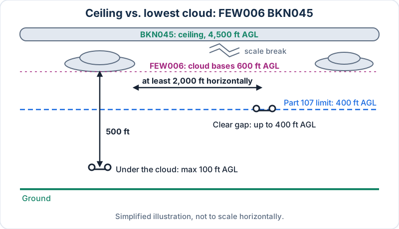 FEW clouds aren't a ceiling, but they still set your clearance. Simplified illustration.
Part 107 check. Directly beneath one of those 600 ft clouds, the most you can climb is 600 − 500 = 100 ft AGL. FEW means widely spaced clouds, so you may find a clear area at least 2,000 ft horizontally from every cloud and fly up to 400 ft. You have to judge that on site.
Example 5: winter snow
METAR KXRD 041753Z 33012KT 1 3/4SM -SN BKN014 OVC022 M03/M06 A3004 RMK AO2 SNB32 SLP178
Wind 330° at 12 kt. Visibility 1 3/4 SM in light snow. Broken at 1,400 ft (ceiling), overcast at 2,200 ft. Temperature −3 °C, dewpoint −6 °C. Snow began at 1732.
Part 107 check. 1 3/4 SM is below 3 SM. No go, and cold batteries plus wet snow are their own problem.
Example 6: a clear, calm morning
METAR KXRE 220853Z VRB03KT 10SM CLR 08/M02 A3021 RMK AO2 SLP236 T00811017
Wind variable at 3 kt. Visibility 10 SM. CLR: the automated sensor detected no clouds at or below 12,000 ft. Temperature 8 °C, dewpoint −2 °C, a 10 °C spread. Precise values 8.1 °C and −1.7 °C.
Part 107 check. Go. Just remember CLR says nothing about clouds above 12,000 ft, and it doesn't matter for a 400 ft flight.
Applying Part 107 minimums to a METAR
Here's the one-minute method I teach:
- Type and time. Is it a SPECI? Is it recent? Convert UTC to local.
- Visibility. At least 3 SM?
P6SMand10SMpass;2 1/2SMfails. - Lowest cloud of any coverage. Subtract 500 ft. If you'll be under it, that's your cap.
- Altitude limit. Apply 400 ft AGL, or the structure exception in §107.51(b) (opens in a new tab).
- Wind and weather. Gusts,
TS,VC,FZ,+: within your aircraft's limits and your judgment? - Trend. Check the TAF and any recent SPECIs for your flight window.
One caveat the test likes: §107.51 visibility is flight visibility from your control station. The METAR describes the airport, which may be miles away. It's evidence, not the final answer. The other operating limits are summarized in the FAA regulations lesson.
How to read a TAF
Header and valid period
TAF KXRA 141130Z 1412/1512 22012KT P6SM SCT040
     FM141600 24015G25KT P6SM BKN035
     TEMPO 1418/1421 3SM -TSRA BKN020CB
     FM142200 30018G28KT 5SM -SHRA OVC015 PROB30 1500/1504 2SM TSRA BKN008CB
     FM150500 31010KT P6SM SCT050
TAF KXRA 141130Z is the forecast for KXRA issued on the 14th at 1130 UTC. 1412/1512 is the valid period: from the 14th at 1200 UTC to the 15th at 1200 UTC. Scheduled TAFs are issued four times a day (0000, 0600, 1200 and 1800 UTC). A TAF AMD supersedes the previous forecast as soon as it's issued. NWS TAFs don't include temperature, and CB is the only cloud type forecast.
Change groups
| Group | What it means |
|---|---|
FMddhhmm |
From this time, a complete new forecast. Every element is repeated and all earlier conditions are replaced |
TEMPO ddhh/ddhh |
Temporary fluctuations, more than 50% likely, each lasting 1 hour or less, together covering less than half the period. Only changing elements are listed |
PROB30 ddhh/ddhh |
A 30% chance of a thunderstorm or precipitation event and its effects. The only PROB group in NWS TAFs, and only one per forecast period |
WShhh/dddffKT |
Non-convective low-level wind shear from the surface up to 2,000 ft AGL, placed after the clouds |
BECMG |
Gradual change; seen in TAFs from some joint civil/military airports, not standard NWS TAFs |
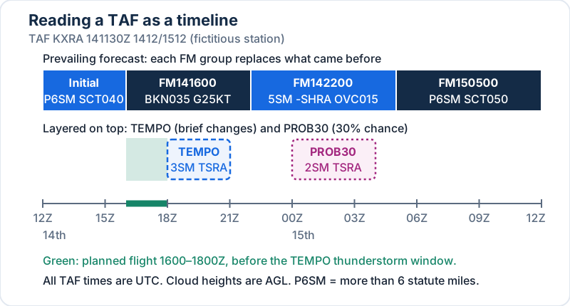 The same TAF as a timeline. FM groups replace each other; TEMPO and PROB30 sit on top. Fictitious station.
Decoding the example TAF
- Initial period (1200–1600Z): wind 220° at 12 kt, more than 6 SM, scattered at 4,000 ft.
- FM141600: from 1600Z, wind 240° at 15 gusting 25, more than 6 SM, broken at 3,500 ft.
- TEMPO 1418/1421: between 1800 and 2100Z, brief drops to 3 SM in thunderstorms with light rain, broken at 2,000 ft with cumulonimbus.
- FM142200: from 2200Z, wind 300° at 18 gusting 28, 5 SM in light rain showers, overcast at 1,500 ft.
- PROB30 1500/1504: 30% chance from 0000 to 0400Z on the 15th of 2 SM in thunderstorms and rain, broken at 800 ft with cumulonimbus.
- FM150500: from 0500Z, wind 310° at 10 kt, more than 6 SM, scattered at 5,000 ft.
Planning read. A flight from 1600 to 1800Z looks workable, though 25 kt gusts may exceed your aircraft's limits. From 1800 to 2100 the TEMPO puts thunderstorms on the field. Three SM technically meets the visibility minimum, but a thunderstorm makes it a no go. After 2200 the clouds drop and storms are possible overnight.
A second TAF: wind shear over a calm morning
TAF KXRB 080520Z 0806/0906 VRB04KT P6SM SKC WS015/24035KT
     TEMPO 0810/0813 4SM BR
     FM081500 19010KT P6SM SCT060
The surface wind is light and variable, but WS015/24035KT warns of wind shear at 1,500 ft AGL, where the wind is 240° at 35 kt. That's the signature of a nighttime inversion. The TEMPO brings brief mist (4 SM still meets the minimum). At 1500Z the FM group replaces everything, so the wind shear no longer applies. For a 400 ft drone, the shear layer is well above you, but the inversion top can be lower than forecast. Climb carefully.
Where to get METARs and TAFs
The NWS Aviation Weather Center at aviationweather.gov is the primary free source, and its data help page (opens in a new tab) documents both formats. Flight Service at 1800wxbrief.com also provides them in online briefings. Many drone apps display METARs too, but check the raw report when the decision is close.
Common METAR and TAF traps
- Using the ceiling instead of the lowest cloud for the 500 ft rule.
- Treating cloud heights as MSL. They're AGL.
- Reading
Mas missing. In temperatures it's minus. - Mixing up true and magnetic. METAR and TAF winds are true.
- Reading
1 1/2SMas 11/2. The space separates whole miles. - Treating
P6SMas exactly 6. It's more than 6. - Thinking TEMPO replaces the forecast. Only FM does.
- Forgetting UTC. Every time in both reports is Zulu.
Practice questions
1. METAR KXRD 101651Z 33008KT 4SM BR SCT008 OVC014 09/08 A2999. What's the highest a small UA can fly while remaining beneath the clouds?
- A. 300 ft AGL
- B. 400 ft AGL
- C. 900 ft AGL
Show answer
A. The lowest cloud is SCT at 800 ft. 800 − 500 = 300 ft AGL. The overcast at 1,400 ft is the ceiling, but it isn't the controlling layer.
2. What does VV004 indicate?
- A. Variable visibility of 4 SM
- B. An indefinite ceiling with vertical visibility of 400 ft
- C. Visibility varying between 0 and 4 SM
Show answer
B. VV is vertical visibility into an indefinite ceiling (a totally obscured sky), in hundreds of feet AGL.
3. In a TAF, TEMPO 0220/0223 2SM -SHRA means
- A. from 2000 UTC the prevailing visibility becomes 2 SM
- B. temporary fluctuations to 2 SM in light rain showers between 2000 and 2300 UTC on the 2nd
- C. a 20% chance of 2 SM between 2000 and 2300 UTC
Show answer
B. TEMPO describes temporary fluctuations, each expected to last an hour or less, within the stated period.
Drill more of these on the free Part 107 practice test.
Frequently asked questions
What is the difference between a METAR and a TAF?
A METAR reports the weather observed at an airport, usually every hour. A TAF forecasts the weather within 5 statute miles of the airport's runway complex, usually for 24 hours (30 at some major airports). They use the same codes. For a drone job you need both: the METAR for conditions now, the TAF for your flight window.
Are METAR cloud heights AGL or MSL?
METAR and TAF cloud heights are above ground level (AGL), in hundreds of feet. BKN035 means broken clouds 3,500 ft above the station. That makes the Part 107 math simple: subtract 500 ft from the lowest cloud to get your maximum height beneath it. Sectional chart altitudes, by contrast, are mostly MSL.
What counts as a ceiling in a METAR?
The ceiling is the lowest layer reported as broken (BKN) or overcast (OVC), or the vertical visibility (VV) into an obscured sky. FEW and SCT layers are never a ceiling. For Part 107, though, cloud clearance applies to any cloud, so the lowest layer of any coverage is the one that limits you.
What does AUTO mean in a METAR?
AUTO means the report came from a fully automated station with no human input. In the remarks, AO1 means the station has no precipitation discriminator, and AO2 means it does, so it can tell rain from snow. Automated stations report CLR when they detect no clouds at or below 12,000 ft.
What is the difference between FM and TEMPO in a TAF?
FM starts a complete new forecast at a specific time and replaces everything before it. TEMPO describes temporary changes, each expected to last an hour or less and together covering less than half the stated period, after which the prevailing forecast resumes. Only the elements that change appear in a TEMPO group.
Do I need to check a METAR before every Part 107 flight?
Part 107 doesn't name a specific product, but §107.49 requires you to assess local weather conditions before every flight, and a nearby METAR and TAF are the easiest official way to do it. Combine them with what you see from the site, since the airport may be miles away.
Weather decoding is a reliable source of exam points once it's practiced. Build it into your Part 107 study plan, and if you want guided drills, the Part 107 course has a full METAR and TAF lesson. The Part 107 study guide lists the other test topics.
Sources
- 14 CFR §107.51 — Operating limitations for small unmanned aircraft
- FAA-H-8083-28B, Aviation Weather Handbook — Chapter 24 (Observations) and Chapter 27 (Forecasts)
- NWS Aviation Weather Center — Data help (METAR and TAF format)
- NWS Aviation Weather Center — METAR data
- NWS Aviation Weather Center — TAF data
- FAA-H-8083-25C, Pilot's Handbook of Aeronautical Knowledge — Chapter 13, Aviation Weather Services