
Part 107 Airspace Classifications: Drone Classes and LAANC
Under §107.41, a Part 107 pilot needs prior ATC authorization to fly in Class B, C, or D airspace or in a Class E surface area for an airport. Class G, and Class E that starts at 700 or 1,200 ft AGL, need no authorization. Most pilots get authorization through LAANC; FAADroneZone is the manual alternative.
Part 107 drone pilots need prior ATC authorization to fly in Class B, C, or D airspace, or a Class E surface area for an airport (§107.41). Class G, and Class E that starts at 700 or 1,200 ft AGL, need no authorization at all. Most pilots get authorization in minutes through LAANC, and FAADroneZone handles everything LAANC can't.
That one rule explains most airspace questions on the knowledge test. The hard part isn't memorizing it. It's reading a sectional chart well enough to know which airspace sits above your launch point, and at what altitude.
Key takeaways
- Authorization required: Class B, Class C, Class D, and a Class E surface area (dashed magenta line). Nothing else in §107.41.
- No authorization: Class G, and Class E with a floor above the surface. At 400 ft AGL you stay under a 700-ft or 1,200-ft Class E floor.
- Weather minimums don't change by class. Part 107 uses 3 SM visibility and 500 ft below / 2,000 ft horizontally from clouds everywhere.
- Shelf labels are MSL. Add ground elevation to your planned AGL altitude before comparing.
- LAANC gives near-real-time approval at or below the UAS Facility Map altitude. Higher requests, up to 400 ft, go through further coordination or FAADroneZone.
- Authorization isn't the whole check. TFRs, prohibited and restricted areas, and NOTAMs apply in every class.
Controlled vs. uncontrolled airspace: what changes for a drone
Controlled airspace is airspace where air traffic control provides service: Classes A, B, C, D and E. Uncontrolled airspace is Class G. If you want a gentler first pass, the free lesson on controlled vs. uncontrolled airspace covers the basics.
Two things trip people up here.
First, "controlled" doesn't mean "authorization required." Most Class E starts at 700 or 1,200 ft AGL. A drone at 400 ft AGL flies underneath it, in Class G, and doesn't need anyone's permission.
Second, the class doesn't change your weather minimums. Manned VFR pilots use the §91.155 table, which differs by class. Under Part 107, the §107.51 operating limits apply the same limits in Class G as in Class B.
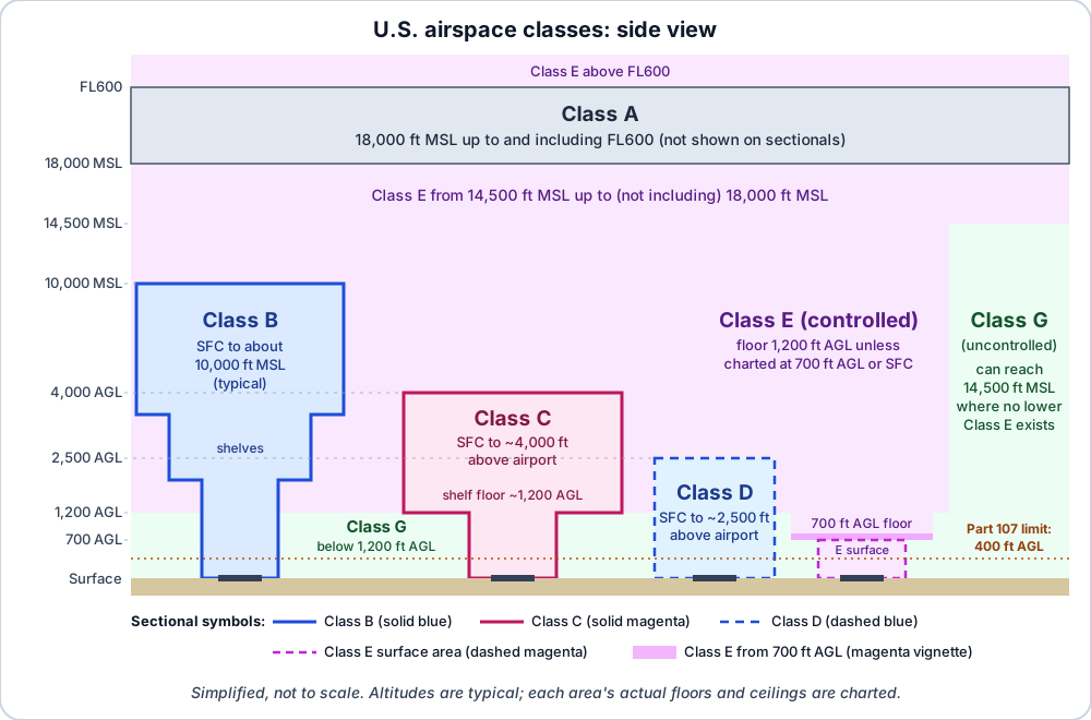
Simplified side view of U.S. airspace. Altitudes are typical values from the AIM; every Class B, C and D area is individually tailored and charted. Not to scale.
Part 107 airspace classes compared
| Class | Typical floor | Typical ceiling | Sectional symbol | ATC authorization for Part 107? |
|---|---|---|---|---|
| A | 18,000 ft MSL | FL600 | Not charted on sectionals | N/A, far above Part 107 |
| B | Surface (shelves higher) | About 10,000 ft MSL | Solid blue | Yes |
| C | Surface (shelf no lower than 1,200 ft above airport) | About 4,000 ft above airport | Solid magenta | Yes |
| D | Surface | About 2,500 ft above airport | Dashed blue | Yes, while in effect |
| E surface area | Surface | Overlying airspace | Dashed magenta | Yes |
| E (other) | 700 ft AGL, 1,200 ft AGL, or 14,500 ft MSL | Up to, not including, 18,000 ft MSL | Magenta or blue vignette, or none | No |
| G | Surface | Overlying Class E floor | No boundary line | No |
Class A runs from 18,000 ft MSL up to and including FL600. Everyone in it flies IFR, sectionals don't show it, and you'll never reach it with a small drone. The exam may still ask where it starts.
Class B airspace
Class B surrounds the busiest airports. The AIM describes it as generally surface to 10,000 ft MSL, individually tailored, with a surface area and two or more layers. Some resemble an upside-down wedding cake.
On a sectional, Class B is a solid blue line. Each sector shows its ceiling over its floor in hundreds of feet MSL. 100/SFC is surface to 10,000 ft MSL. 100/40 is 4,000 to 10,000 ft MSL. A floor shown with a plus sign means the airspace starts above that altitude, and you're outside it at and below that number.
The thin solid magenta circle about 30 NM out is the Mode C veil. It's an equipment rule for manned aircraft, not an airspace class, and it doesn't trigger §107.41 on its own.
For Part 107: you need authorization in the surface area and in any shelf your altitude reaches. Under a shelf whose floor is above your maximum MSL altitude, you aren't in Class B.
Class C airspace
Class C surrounds airports with an operating control tower, radar approach control, and enough traffic. Per the AIM it usually has:
- a 5 NM radius core from the surface to 4,000 ft above the airport elevation, and
- a 10 NM radius shelf that extends no lower than 1,200 ft up to 4,000 ft above the airport.
It's drawn in solid magenta, with MSL labels such as 48/SFC for the core and 48/25 for the shelf. There's also a procedural Outer Area, normally 20 NM out. It isn't charted as Class C, and it isn't part of Class C.
For Part 107: authorization in the core, and in the shelf if your altitude enters it.
Class B vs Class C: the differences that get tested
| Class B | Class C | |
|---|---|---|
| Line on the sectional | Solid blue | Solid magenta |
| Typical ceiling | About 10,000 ft MSL | About 4,000 ft above the airport |
| Typical shape | Surface area plus two or more layers | 5 NM core plus 10 NM shelf |
| Extra ring you might confuse with it | 30 NM Mode C veil (thin magenta circle) | 20 NM Outer Area (not charted) |
| Part 107 authorization | Required inside | Required inside |
For a drone pilot, the operational answer is the same: authorization inside, none underneath a shelf you don't reach. The exam questions are about identifying which one you're looking at and reading the numbers.
Class D airspace and part-time towers
Class D surrounds airports with an operating control tower. The AIM puts it at generally surface to 2,500 ft above the airport elevation, charted in MSL. It's shown with blue segmented (dashed) lines, and its ceiling appears in a dashed box, such as [28] for 2,800 ft MSL. A minus sign, as in [-28], means up to but not including that altitude. You usually see it where Class D tucks under a Class B or C shelf.
Many towers close at night. When they do, the Chart Supplement says what the airspace becomes: "other times CLASS E" or "other times CLASS G." This is a favorite exam question:
- Tower open: Class D, so authorization required.
- Tower closed, reverts to Class E surface area: still required.
- Tower closed, reverts to Class G: not required.
Dashed lines sometimes stick out from a surface area to protect instrument approaches. The AIM says Class D extensions of 2 NM or less stay part of the Class D surface area. If any one is longer, all of them become Class E, drawn in dashed magenta. Either way, plan as if authorization is required and confirm in your LAANC app.
Class E airspace: the floor decides everything
Class E is any controlled airspace that isn't A, B, C or D. For drone pilots, only one question matters: where does it start?
| Class E type | Floor | How the sectional shows it | Authorization at or below 400 ft AGL? |
|---|---|---|---|
| Surface area for an airport | Surface | Dashed magenta line | Yes (§107.41) |
| Extension to a surface area | Surface | Dashed magenta, attached to the surface area | Treat as yes, and confirm |
| Transition area | 700 ft AGL | Magenta vignette (shaded band) | No, you're in Class G below it |
| General Class E | 1,200 ft AGL | Blue vignette next to Class G; otherwise the default | No |
| Federal (Victor) airways | 1,200 ft AGL | Airway centerlines | No |
| Upper Class E | 14,500 ft MSL (also above FL600) | Not specially marked | No |
A Class E surface area exists around some non-towered airports with weather reporting and communications down to the runway. It's also what a part-time Class C or D becomes when the Chart Supplement says "other times CLASS E."
The mix-up to avoid: a magenta vignette (a soft shaded band) means 700 ft AGL. A magenta dashed line means the surface. One is no authorization; the other needs it. The sectional charts lesson has more practice reading both.
Class G airspace
Class G is everything not designated A through E. Near the ground it usually runs from the surface up to the overlying Class E floor, normally 700 or 1,200 ft AGL. In remote areas with no lower Class E, it can extend as high as 14,500 ft MSL.
You need no ATC authorization in Class G and you don't call anyone. Every other Part 107 rule still applies: 400 ft AGL, visual line of sight, weather minimums, right of way, TFRs.
Do I need authorization? A four-step check
Here's the sequence I'd run for any job site, in this order:
- Find the site on a current chart or LAANC app. Note every line and shaded band you're inside.
- Is any part of the flight in B, C, D, or a dashed-magenta Class E surface area? If no, §107.41 doesn't apply.
- If you're under a B or C shelf, do the MSL math. Ground elevation plus your maximum AGL altitude. Is that below the shelf floor?
- Check everything that isn't airspace class. TFRs, prohibited and restricted areas, stadium restrictions and NOTAMs.
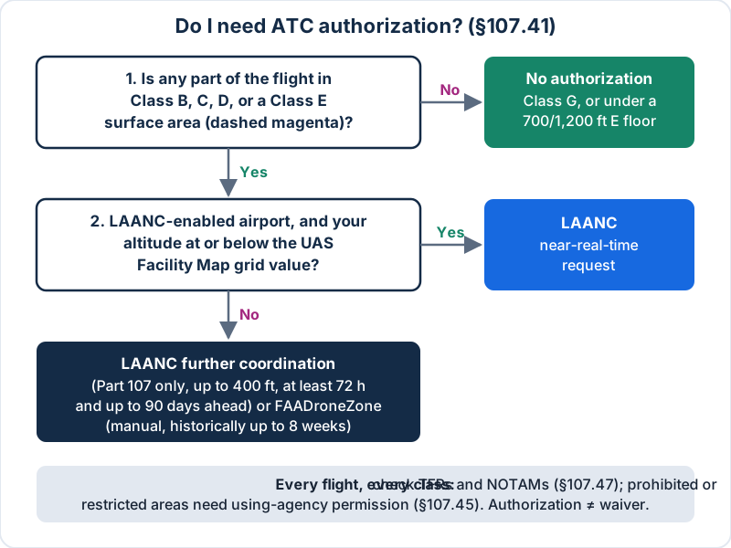
Deciding whether §107.41 applies and which authorization path to use. Simplified illustration.
How LAANC authorization works for Part 107 pilots
LAANC (Low Altitude Authorization and Notification Capability) is part of the FAA's UAS Data Exchange. You don't apply on an FAA website. You use a desktop or mobile app from an FAA-approved UAS Service Supplier. According to the FAA's LAANC page (opens in a new tab), each request is checked against UAS Facility Maps, special use airspace data, airports and airspace classes, TFRs and NOTAMs.
Near-real-time vs. further coordination
| Near-real-time | Further coordination | |
|---|---|---|
| Altitude | At or below the UAS Facility Map grid value | Above the grid value, up to 400 ft (including 0-ft grids, except on-airport operations) |
| Who can use it | Part 107 and recreational flyers | Part 107 pilots only |
| Review | Automated | An air traffic manager reviews it |
| When to submit | On the day you fly | At least 72 hours before start; up to 90 days ahead |
Unless the authorization says otherwise, you don't need to call the tower before you fly. And LAANC is an airspace authorization only. You still check NOTAMs and weather yourself.
FAADroneZone
FAADroneZone (opens in a new tab) handles airports that aren't LAANC-enabled, and it can process requests at LAANC airports too, just not in near-real time. Requests are reviewed manually. The FAA's Part 107 airspace authorizations page (opens in a new tab) says processing has historically taken up to eight weeks. Plan for that on any job with a fixed date.
UAS Facility Maps
UAS Facility Maps (opens in a new tab) divide the controlled airspace around airports into grid squares. Each square shows the maximum altitude at which the FAA may authorize Part 107 flights without further safety analysis. The FAA is blunt that the maps do not authorize anything. They're for planning.

Special use airspace, TFRs, and other restrictions
These don't depend on airspace class. They can sit on top of Class G as easily as Class B. The FAA's special use airspace section of the AIM (opens in a new tab) defines each one.
| Area | Chart label | What a drone pilot must do |
|---|---|---|
| Prohibited area | P-### | Permission from the using or controlling agency (§107.45) |
| Restricted area | R-#### | Permission from the using or controlling agency (§107.45) |
| Warning area | W-### | Caution; begins 3 NM off the coast |
| Military Operations Area | Name + "MOA" | Caution; no permission required |
| Alert area | A-### | Caution; high volume or unusual activity |
| Controlled Firing Area | Not charted | Activity stops when aircraft approach |
| National Security Area | Charted, voluntary avoidance | Flight may be prohibited by NOTAM under §99.7 |
TFRs are issued by NOTAM for disasters, VIP movements, space launches, sporting events and more. §107.47 requires you to comply with §§91.137 through 91.145 and §99.7. Sectionals show only national-security TFRs, so check the FAA TFR site (opens in a new tab) and NOTAMs before every flight. Large stadium events carry a standing restriction, generally 3 NM and up to 3,000 ft AGL, from one hour before to one hour after the event. The AIM section on TFRs (opens in a new tab) has the details.
Last, §107.43: don't interfere with traffic patterns at any airport, heliport or seaplane base, controlled or not. A Class G airstrip still has a pattern.
Worked examples
Example 1: Under a Class C shelf. A roof inspection site is 7 NM from a Class C airport. The shelf above is labeled 46/18, and the ground at the site is 650 ft MSL. Your highest point is 650 + 400 = 1,050 ft MSL, which is 750 ft below the shelf floor. You're beneath Class C. Check what lies under the shelf. If it's Class G under a Class E floor, no authorization is needed.
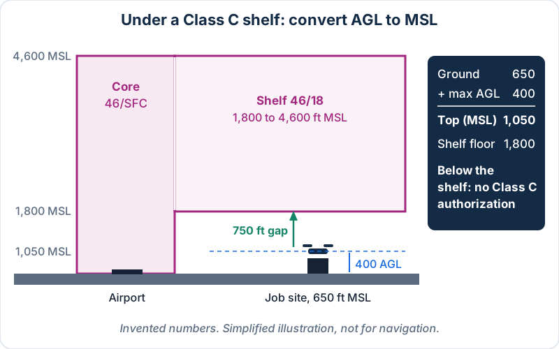
Converting AGL to MSL under a Class C shelf. Invented numbers; simplified illustration, not for navigation.
Example 2: A part-time tower after hours. A Class D tower closes at 2200 local, and the Chart Supplement says "other times CLASS E." At 2230 the airport has a Class E surface area, so §107.41 still applies. If it said "other times CLASS G," you'd need nothing.
Example 3: Inside a magenta vignette. Your site is inside a magenta vignette but outside every dashed or solid line. Class E starts at 700 ft AGL, so at 400 ft AGL you're in Class G. No authorization.
Example 4: Above the grid. You need 250 ft AGL to inspect a cell tower inside Class D, and the Facility Map grid shows 200. A near-real-time request at 200 ft would work. At 250 ft you need further coordination, at least 72 hours ahead, or a FAADroneZone request.
Common airspace mistakes on the exam
- Treating all controlled airspace alike. Only B, C, D and Class E surface areas trigger §107.41.
- Comparing AGL to MSL. Shelf and ceiling labels are MSL. Convert first.
- Confusing the Mode C veil with Class B. The veil is an equipment ring, not airspace you need permission to enter.
- Forgetting part-time towers. Check the Chart Supplement for what the airspace becomes.
- Applying §91.155 cloud clearances. Part 107 uses §107.51 in every class.
- Thinking a waiver is how you get into controlled airspace. It's an authorization. A waiver changes a rule.
- Assuming the chart shows everything. CFAs and most TFRs aren't charted.
Practice question
A remote pilot plans to fly at 300 ft AGL inside a dashed blue boundary while the tower is operating. What is required?
- A. Nothing, as long as the drone stays below 400 ft AGL
- B. Prior authorization from ATC
- C. A certificate of waiver under §107.205
Show answer
B. A dashed blue line marks Class D. §107.41 requires prior ATC authorization, usually through LAANC or FAADroneZone. The 400-ft limit isn't an exception, and a waiver isn't the mechanism for airspace access.
Frequently asked questions
What airspace can I fly a drone in without authorization?
You can fly without ATC authorization in Class G airspace and anywhere Class E starts above the surface, such as under a 700-ft or 1,200-ft AGL floor. At or below 400 ft AGL, that covers most of the country away from airports. You still have to follow every other Part 107 rule and check TFRs and special use airspace.
What is the difference between Class B and Class C airspace?
Class B surrounds the busiest airports, usually reaches about 10,000 ft MSL, and is drawn with solid blue lines. Class C surrounds busy airports with radar approach control, usually reaches about 4,000 ft above the airport, and is drawn with solid magenta lines. Part 107 requires ATC authorization to fly in either one.
Do I need LAANC for Class E airspace?
Only if it's a Class E surface area, shown with a dashed magenta line on the sectional. Class E with a 700-ft or 1,200-ft AGL floor starts above where a drone normally flies, so you're in Class G underneath it. Your LAANC app will show whether a location is inside a surface area.
How long does LAANC approval take?
LAANC near-real-time requests at or below the UAS Facility Map altitude are usually approved almost immediately. Further coordination requests, which let Part 107 pilots ask for up to 400 ft, must be submitted at least 72 hours ahead and can go in up to 90 days early. FAADroneZone requests are manual and have historically taken up to eight weeks.
Is Class G airspace safe to fly in without checking anything?
No, Class G only means you don't need ATC authorization. You still need to check TFRs, NOTAMs, prohibited and restricted areas, and nearby airport traffic patterns. All of Part 107 still applies, including the 400-ft limit, visual line of sight and the §107.51 weather minimums.
Does a UAS Facility Map authorize me to fly?
No, a UAS Facility Map never authorizes a flight on its own. It shows the maximum altitude the FAA may approve in each grid square without extra safety analysis. You still need an authorization through LAANC or FAADroneZone before you fly in Class B, C, D or a Class E surface area.
Keep studying
Airspace questions usually come with a sectional excerpt, so the next step is reading real charts. Pair this page with the sectional charts lesson and the Part 107 rules most often tested, then try timed airspace questions on the free Part 107 practice test. The Part 107 study guide shows where airspace fits among the other exam topics, and the Part 107 course has a full airspace module with chart drills. The rule itself is short enough to read in full: 14 CFR §107.41 (opens in a new tab).
Sources
- 14 CFR §107.41 — Operation in certain airspace
- 14 CFR §107.45 — Operation in prohibited or restricted areas
- 14 CFR §107.47 — Flight restrictions in the proximity of certain areas designated by notice to airmen
- FAA Aeronautical Information Manual, Chapter 3, Section 2 — Controlled Airspace
- FAA Aeronautical Information Manual, Chapter 3, Section 4 — Special Use Airspace
- FAA Aeronautical Information Manual, Chapter 3, Section 5 — Other Airspace Areas (TFRs)
- FAA Aeronautical Chart Users' Guide (VFR Terms and Symbols)
- FAA — UAS Data Exchange (LAANC)
- FAA — Part 107 Airspace Authorizations
- FAA — UAS Facility Maps
- FAA — Temporary Flight Restrictions
- FAADroneZone